
If you’ve ever used a navigation app and it sometimes took you off course, the culprit is 80-300 kilometers over your head. This region of Earth’s atmosphere called the ionosphere can contain many levels of electrons, which in high concentrations can slow GPS signals traveling between satellites and device owners.
In a research paper published a few hours ago in the journal Nature, Google researchers showed in the most characteristic way that they were able to take measurements from millions of Android devices (anonymously, of course) in an attempt to map the circulation of the ionosphere through a high-quality network ground stations. Although the signal from a mobile device can be noisy as the scientists explain this noise is corrected when there are multiple devices to compare.
So they used millions of devices to be able to map the ionosphere in a valid way corresponding to ground stations. Scientists can measure ionospheric circulation through high-precision ground stations. However, the problem is that these tools are difficult to produce due to their cost in developing countries, resulting in a difference in the accuracy of ionosphere mapping worldwide. And that’s how they solved it by using tools that the whole world uses, cell phones. Google researcher and paper author Brian Williams told Popular Science that he had previously seen firsthand how changes in the ionosphere could hinder GPS capabilities while working on Android products.
He says he saw this project as an opportunity to simultaneously contribute to scientific progress and improve accuracy for everyday mobile users. Modern smartphones come equipped with GPS receivers that receive the signal from satellites in orbit. The receivers calculate the distance between them and the satellites to determine the location with an accuracy of 4 meters. These signals travel quickly and unhindered through space until they reach the ionosphere. This part of the upper atmosphere can be in different states based on variables such as season, time of day, or distance from the equator, which can ultimately contribute to GPS accuracy errors.
The Google researchers wanted to see if measurements taken from Android mobile phones could essentially replicate the mapping of the ionosphere done at more advanced monitoring stations. It is worth noting that monitoring stations have a clear advantage over mobile phones. For starters, they have much larger antennas than cell phones. They are also usually under clear, open skies, unlike mobile phones which are often blocked by urban buildings or the user’s pocket. Each individual phone also has its own measurement inaccuracy. However, the weaknesses of smartphones are compensated by their sheer number. The researchers collected GPS signals from millions of mobile phones around the world to create a map of electrons in the ionosphere. They then compared the map they created from the measurements they got from the cellphones with measurements from a database of monitoring stations around the world.
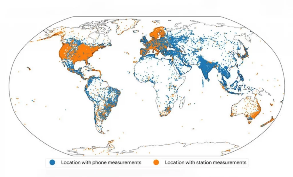
Google’s method of harnessing mobile data has greatly expanded coverage, particularly in areas of India and Eastern Europe where there is a lack of monitoring stations. In the image, the blue dots show about 100,000 locations around the world where a sufficient number of telephone measurements were available to help map the ionosphere.
All this has a purpose. To make GPS much more accurate for all users on the planet.
0 Comments